A developing tropical storm system is expected to bring severe weather conditions across New Zealand, including strong winds, heavy rainfall, and potential disruptions.
The system, which recently reached tropical cyclone strength, is now moving south out of the tropics and into the Tasman Sea, where it is forecast to intensify before weakening later this week.
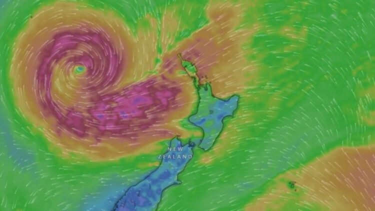
Storm Transitioning from Tropics to Tasman Sea
The weather system began as a tropical cyclone, although it was not officially named by the Fiji Meteorological Service. However, the Joint Typhoon Warning Center (JTWC) confirmed that it had reached cyclone status earlier.
As the system moves away from tropical waters, it is undergoing a transition into a larger and more complex storm system. During this phase:
- The storm is expected to expand in size
- Wind fields may become more widespread
- Rain bands could cover larger regions of the country
This transition increases the likelihood of nationwide impacts, even if the storm itself weakens later.
Severe Weather Risks Across New Zealand
Meteorologists have warned that severe weather risks will be highest in the northern regions of both the North and South Islands.
Key Expected Impacts:
- Gale-force winds, particularly in exposed coastal areas
- Heavy rainfall, raising the risk of flooding in some regions
- Damaging wind gusts, especially in areas facing north-easterly winds
While the worst conditions are likely in the north, strong winds could extend across much of the country, depending on how the system develops.
Wind and Rain Forecast Details
Forecast models indicate that the storm will bring intense bursts of rain and strong wind patterns, although exact impacts may vary by region.
Weather experts have released preliminary wind and rainfall maps, but these are expected to be refined further in the coming days as the system evolves.
Areas Most at Risk:
- Northern North Island: Higher chance of heavy rain and strong winds
- Upper South Island: Potential for significant wind gusts
- Exposed coastal regions: Greater vulnerability to gale conditions
Some Areas May Avoid the Worst Conditions
Despite the widespread concern, not all parts of New Zealand will experience severe impacts.
Meteorologists have indicated that:
- Some regions may see lighter rainfall
- Wind strength may vary significantly depending on local geography and exposure
- Inland and sheltered areas could avoid the most intense conditions
This uneven distribution highlights the importance of localized forecasts and updates.
Official Warnings and Preparedness
New Zealand’s MetService has already begun issuing weather watches and warnings ahead of the approaching storm.
Authorities are urging residents to:
- Stay updated with official weather alerts
- Prepare for possible travel disruptions
- Secure outdoor items that could be affected by strong winds
- Monitor flood-prone areas if heavy rain develops
The situation remains dynamic, and forecasts will continue to be fine-tuned as new data becomes available.
Storm Expected to Weaken by Weekend
The storm is forecast to move towards the West Coast of the South Island by Saturday. As it does so, it is expected to:
- Lose strength gradually
- Break apart into a weaker weather system
However, even as it weakens, the system may still bring residual rain and wind to some regions.
The approaching tropical storm system poses a significant weather event for New Zealand, particularly for northern regions. With gales, heavy rain, and widespread wind risks, residents are advised to stay alert and prepared.
While not all areas will experience severe impacts, the evolving nature of the storm means conditions could change quickly. Ongoing updates from MetService will be crucial in the coming days as the system tracks across the country.